Categoria: Wordpress Plugin

  • [WordPress Plugin Directory] Notice: WP GPX Maps – temporarily disabled

    This morning I received the email below, I’ll try to replace Highcharts with Google chart tools soon.

    Upon review, your plugin has been found to be in violation of the directory guidelines, found at

    https://developer.wordpress.org/plugins/wordpress-org/detailed-plugin-guidelines/

    It’s required that all code be compatible with GPL to be included in our directory.

    Highcharts and their add ons have been licensed Creative Commons.

    Please remove the code and alter the plugin so it is not required. If you cannot alter the code, we suggest you find alternate code that is GPL compatible and use that instead. For more information on what types of licenses are compatible with GPL, please review the following links:

    http://www.gnu.org/licenses/license-list.html
    http://www.gnu.org/licenses/gpl-faq.html#AllCompatibility

    Plugins are closed immediately and the developer contacted when this happens, in part because we have an imperfect system of notifications. This means until your plugin is corrected to meet our guidelines, we will not reopen it. Once you have corrected the issue, checked the code into SVN, and increased your plugin’s version number, please reply and let us know. At that time we will re-review your code (not just the changes, but the entire plugin), so there may be a delay.

    Your plugin will not be re-opened until it is reviewed, and it won’t be reviewed until you reply to this email, so please do so as soon as you’ve corrected the issue(s).

    If you have any questions, please let us know.

    https://wordpress.org/plugins/wp-gpx-maps/


  • WP GPX Maps

    This plugin has, as input, the GPX file with the track you’ve made and as output it shows the map of the track and an interactive altitude graph (where available).

    Fully configurable:

    • Custom colors
    • Custom icons
    • Multiple language support

    NextGen Gallery Integration:

    Display your NextGen Gallery images inside the map! Even if you don’t have a gps camera, this plugin can retrive the image position starting from the image date and you gpx file.

    Old NGGallery Images (without gps data) and gpx: http://www.pedemontanadelgrappa.it/mappe/itinerario-3-alta-via-degli-eroi/

    Translated into 7 languages:

    • English (default)
    • Italian it_IT
    • German de_DE
    • Spanish es_ES
    • Dutch nl_NL
    • Swedish sv_SE
    • Turkish tr_TR

    (many thanks to all the guys who helped me with the translations)

    • iphone/ipad/ipod Compatible

    Try this plugin: http://www.pedemontanadelgrappa.it/category/mappe/

    Support Forum

    Supported gpx namespaces are:

    1. http://www.topografix.com/GPX/1/0
    2. http://www.topografix.com/GPX/1/1
    3. http://www.garmin.com/xmlschemas/GpxExtensions/v3
    4. http://www.garmin.com/xmlschemas/TrackPointExtension/v1

    Thanks to: http://www.securcube.net, http://www.devfarm.it, http://www.pedemontanadelgrappa.it

    Up to version 1.1.15 Highcharts-API is the only available rendering engine. Please respect their license and pricing (only Free for Non-Commercial usage).

    Changelog

    1.1.35

    • Fix: In the post list, sometime, the maps was not displaying correctly ( the php rand() function was not working?? )
    • Various improvements for multi track gpx. Thanks to GPSracks.tv
    • Summary table is now avaiable even without chart. Thanks to David

    1.1.34

    • 2 decimals for unit of measure min/km and min/mi
    • translation file updated (a couple of phrases added)
    • File list reverse order (from the newer to the older)
    • nggallery integration: division by zero fixed

    1.1.33

    • Decimals reducted to 1 for unit of measure min/km and min/mi
    • map zoom and center position is working with waypoints only files
    • automatic scale works again (thanks to MArkus)

    1.1.32

    • You can exclude cache (slower and not recommended)
    • You can decide what show in the summary table
    • German translation (thanks to Ali)

    1.1.31

    • Fixed fullscreen map image slideshow

    1.1.30

    • Multi track gpx support
    • Next Gen Gallery images positions derived from date. You can adjust the date with the shortcode attribute dtoffset
    • If you set Chart Height (shortcode gheight) = 0 means hide the graph
    • Fix: All images should work, independent from browser cache

    1.1.29

    • Decimal separator is working with all the browsers
    • minutes per mile and minutes per kilometer was wrong

    1.1.28

    • Decimal and thousand separator derived from browser language
    • Added summary table (see settings): Total distance, Max elevation, Min elevation, Total climbing, Total descent, Average speed
    • Added 2 speed units of measure: minutes per mile and minutes per kilometer

    1.1.26

    • Multilanguage implementation (only front-end). I’ve implemented the italian one, I hope somebody will help me with other languages..
    • Map Full screen mode (I’m sure it’s not working in ie6. don’t even ask!)
    • Added waypoint custom icon

    1.1.25

    • Added possibility to download your gpx

    1.1.23

    • Security fix, please update!

    1.1.22

    • enable map zoom on scroll wheel (check settings)
    • test attributes in get params

    1.1.21

    • google maps images fixed (templates with bad css)
    • upgrade to google maps 3.9

    1.1.20

    1.1.19

    • include jQuery if needed

    1.1.17

    • Remove zero values from cadence and heart rate charts
    • nextgen gallery improvement

    1.1.16

    • Cadence chart (where available)
    • minor bug fixes

    1.1.15

    • migration from google chart to highcharts. Highcharts are much better than google chart! This is the base for a new serie of improvements. Stay in touch for the next releases!
    • heart rate chart (where available)

    1.1.14

    • added css to avoid map bars display issue

    1.1.13

    • added new types of maps: Open Street Map, Open Cycle Map, Hike & Bike.
    • fixed nextgen gallery caching problem

    1.1.12

    • nextgen gallery display bug fixes


  • WP Silverlight GPX ver 0.1

    WP Silverlight GPX ver 0.1

    New plugin at: http://www.devfarm.it/wordpress-plugin/wp-gpx-maps/wp-gpx-maps/

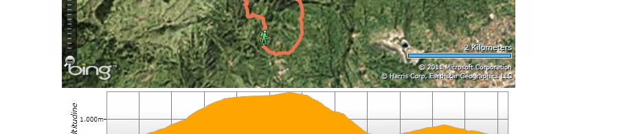
    WP Silverlight GPX shows your trak in the map with altitude graph from a gpx file.

    You can also move the mouse over the altitude graph and check the position in the map.


    Installation:

    Install the plugin as usual and set your Bing Maps Apy Key in the settings.


    Usage:

    Upload your gpx file and then add the shortcode in the articles [sgpx gpx="<relative path to file.gpx>"]:

    [sgpx gpx="/wp-content/gpx/somefile.gpx"]


    See in action:

    http://www.pedemontanadelgrappa.it/mappe/attraversata-del-grappa-da-s-liberale-ad-alano-di-piave/


    Download

    wp-silverlight-gpx.zip


    Other

    In order to save bandwidth and speed up the map loading time, the original GPX file is reduced server side and then sent to the application.

    You need a Bing Maps Api Key, you can generate here: http://www.bing.com/toolbox/bingdeveloper/

    This plugin uses Microsoft Silverlight 4 and Bing Maps Silverlight Control.


    If you find a bug or if you have a request, feel free to contact me..